According to AccuWeather Senior Meteorologist Alex Sosnowski, numerous severe weather incidents may develop across multiple states from Tuesday afternoon through Wednesday evening. These storms could bring strong wind gusts, significant hail, and possibly several dozen tornadoes.
After several days of stormy weather across the region last week, forecasters say the threat is set to intensify again, particularly across areas stretching from the Great Plains to the Mississippi and Ohio valleys. (X: @NWS)
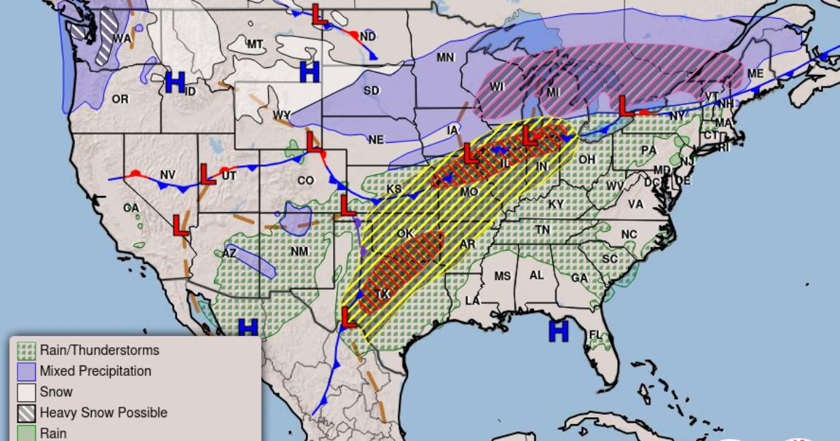
Parts of the central United States are likely to face another spell of severe weather this week, with storms capable of producing damaging winds, large hail, and isolated tornadoes. Meteorologists warn that conditions on Tuesday and Wednesday could trigger a widespread outbreak of severe thunderstorms.
After several days of stormy weather across the region last week, forecasters say the threat is set to intensify again, particularly across areas stretching from the Great Plains to the Mississippi and Ohio valleys.
Scattered severe thunderstorms are forecast Tuesday from the southern Plains into the southern Great Lakes vicinity. Thunderstorms may also produce heavy to excessive rain that could pose a flooding threat from central Texas into southern Oklahoma and northern Missouri into… pic.twitter.com/TgESuSojin
— National Weather Service (@NWS) March 10, 2026
According to AccuWeather Senior Meteorologist Alex Sosnowski, numerous severe weather incidents may develop across multiple states from Tuesday afternoon through Wednesday evening. These storms could bring strong wind gusts, significant hail, and possibly several dozen tornadoes.
He noted that the system will first affect parts of the Mississippi Valley along the Interstate 20 and 40 corridors on Tuesday. The storm activity is then expected to shift southeastward, with locally severe storms reaching parts of the Southeast by Thursday.
A strong storm system moving across the Plains and into the Great Lakes during midweek will interact with warm, moist air from the Gulf and cooler air arriving from the Pacific and Canada. This clash of air masses is expected to produce favorable conditions for severe thunderstorms from Texas to the Ohio Valley.
AccuWeather Senior Meteorologist Adam Douty said the event could become the most significant outbreak of severe weather seen so far this year.
Meteorologists advise residents in vulnerable areas to stay alert and ensure they can receive weather warnings through several sources. Severe storms may continue overnight, raising the risk of nighttime tornadoes that are often harder to detect.
Experts recommend keeping essentials nearby before going to bed, including closed-toe shoes, a flashlight, and fully charged electronic devices.
In addition to strong storms, flash flooding may occur across parts of the Plains and Ohio Valley. Several rounds of storms during the first week of March have already saturated the ground in many areas, increasing the likelihood of flooding. Rising water levels in local rivers and streams are also possible.
The threat of severe thunderstorms is expected to expand Tuesday afternoon and continue into the night across a wide corridor from Texas to southwestern Michigan. Forecasters have highlighted higher-risk zones in parts of Texas and the Midwest.
Major cities that could experience severe weather include Chicago, Dallas, St. Louis, Oklahoma City, Indianapolis, and Kansas City, Missouri.
These storms may produce large hail, damaging wind gusts, and flash flooding. Tornadoes are also possible, with wind gusts outside tornadoes potentially reaching 80 miles per hour.
Douty said the greatest risk of tornado development Tuesday afternoon and night may occur from Missouri to Indiana. The danger zone could extend close to Chicago, particularly its southern suburbs.
Residents across the risk area are encouraged to identify the safest shelter location in homes, schools, or workplaces in case a tornado warning is issued.
Sosnowski stressed that even a single tornado striking a populated area can lead to significant damage and casualties. He urged people to monitor forecasts and severe weather alerts closely, whether they are at home, traveling, or commuting along major highways.
As the storm system shifts toward the Great Lakes, the severe weather threat will also move eastward on Wednesday and Wednesday night. The risk could stretch across more than a dozen states, from eastern Texas to Pennsylvania and western New York.
Forecasters have identified a moderate risk area that includes parts of western Pennsylvania, West Virginia, and Ohio.
Thunderstorms in these regions may bring hail, wind gusts between 60 and 70 miles per hour, and isolated tornadoes. Travelers using airports in the affected areas or driving along major highways such as Interstates 10, 20, 40, 64, and 70 may face delays.
By Thursday, widespread rain showers and gusty thunderstorms are expected to extend from the Gulf Coast toward much of the Atlantic Seaboard, keeping unsettled weather in place for another day.